Project Information
Title: Standardized, High-Resolution, Geospatial Wetlands and Hydrography Data Across the EVOS Region 21210129
Project Year and Number: 2021: 21210129
Other Fiscal Years and Numbers for this Project: 2026: 26220508, 2025: 25220508, 2024: 24220508, 2023: 23220508, 2022: 22220508
Principal Investigator (PI): Leslie Jones (Alaska Dept. of Natural Resources), Sydney Thielke (USFWS), Brian Wright (USGS)
Managing Agency: ADNR
Assisting Personnel: None
Research Location: EVOS Region
Restoration Category: General Restoration, Habitat Protection
Injured Resources Addressed: Not Specified
Abstract:This project develops a comprehensive and ecosystem-based hydrologic framework across the EVOS region. The project deliverables include contemporary National Wetlands Inventory (NWI) and National Hydrography Dataset (NHD) information for use in assessing and monitoring injured resources and services throughout the project area. The final product will be a seamless integration of NWI and NHD datasets, compliant with national standards, into the national geodatabases.
Continuous coverage of high-resolution NWI and NHD products do not exist for the EVOS region and are critically important for continued management and recovery of injured resources and services. This proposal requests $3.87 million dollars to complete high-resolution, publicly available mapping of hydrography, wetlands, and nearshore habitats, consisting of a total of 31million acres (Figures 1 and 2).
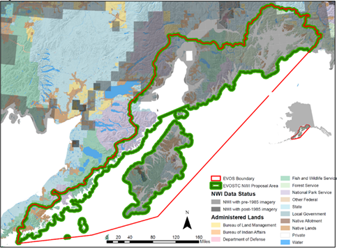
Figure 1 National Wetlands Inventory (NWI) project area
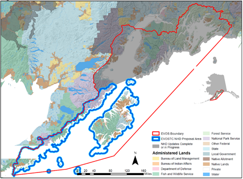
Figure 2 National Hydrography Dataset (NHD) project area
Accurately representing the connectivity of wetland, terrestrial hydrography, estuarine and nearshore habitats allows for an ecosystem approach to managing injured resources and services. The NWI and NHD inform mission critical activities undertaken by government entities (Federal, state, regional, county, local, Tribal), nonprofit organizations, and private companies. Examples of activities informed by NWI and NHD that effect injured resources and services include:
- Manage water such as stream flow and stormwater
- Monitor water quality
- Model and map flood risk
- Conserve terrestrial and aquatic habitats
- Manage fisheries, rangeland, timberlands, and agricultural lands
- Assess coastal hazards
- Plan for future land development activities and infrastructure
- Provide recreational opportunities for citizens
The NWI represents the location, characteristics and extent of wetlands, intertidal, and nearshore marine habitats (Figure 3). The NWI also captures intertidal and nearshore subtidal habitat information such as coastline substrate and the presence of nearshore aquatic vegetation. The NHD dataset documents the location of terrestrial surface waters (i.e., stream, rivers, lakes), their flow paths, and watershed boundaries. Both datasets can be integrated with the previously funded ShoreZone Mapping project to better understand habitats supporting populations of injured resources and aid as a decision-support tool in project planning.
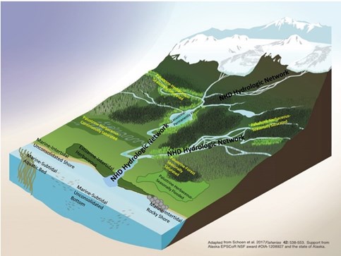
Figure 3 Example characterization of landscape connectivity of wetlands and hydrography
The NWI and NHD are used in Alaska for habitat management, species assessments (including anadromous waters), (Flagstad et. Al 2018, Fellman et. Al 2014, Shanley and Albert 2014), and to inform development activities throughout Alaska (USACE 2015, ADOT&PF 2010). The data serve as the baseline geospatial information needed to monitor aquatic and wetland dependent species, including species such as salmon that move between freshwater, nearshore, and marine habitats. This includes providing information about sensitive estuaries, coastal wetlands and the contribution of freshwater inputs to estuarine and nearshore habitats (i.e., water quality and chemistry). This proposal will provide framework geospatial data (FGDC, 2014) that can be used to assess intertidal systems that support not only habitat for injured resources but also subsistence and recreation activities and services.
Data development will be conducted over a three-year timeframe. Geospatial datasets will be developed and assembled according to national mapping and classification standards and reviewed according to national mapping quality assurance quality control protocols. The NWI and NHD production process will be contracted with experienced professionals that use image interpretation, machine learning and field data collection to create standardized wetland and hydrography products. The primary fiscal agent will be USFWS and the project will be managed by Sydney Thielke (USFWS) with close coordination and assistance provided by Leslie Jones (State of Alaska) and Brian Wright (USGS). Major land managers and owners in the EVOS region have been included in the initial project scoping of this project and coordination will be ongoing.
In the past decade, the Alaska Geospatial Council (AGC) chaired by the Commissioner of AK DNR has represented state mapping interests and the Alaska Mapping Executive Committee (AMEC) chaired by Directors of USGS and NOAA representing federal interests have advocated for consistent baseline geospatial datasets for Alaska. Through active collaboration and coordination, the AGC and AMEC have acquired digital elevation and imagery products for the entire state. Wetlands and hydrography updates, however, still lack funding and coordination, which means that most of Alaska remains unmapped and/or products are extremely out-of-date. If funded, the area within the EVOS boundary will have the most up-to-date high-resolution NWI and NHD that meet national standards of the USFWS and USGS.
Proposal: View (2,248 KB)
Reports:
2021 2nd Quarter Report: View (188 KB)
2021 3rd Quarter Report: View (188 KB)
2021 4th Quarter Report: View (189 KB)
Publications from this Project: None Available
Resolutions: